This article pulls together from a four-part series of flood mitigation blogs detailing the flood resilience policy roadmap for Appalachia, released by ReImagine Appalachia, Appalachian Citizens’ Law Center and the National Wildlife Federation.
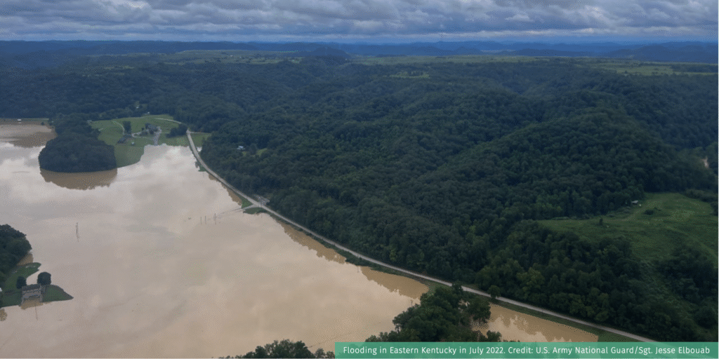

Jenkins, Kentucky, is a fairly small town. Mayor Todd DePriest knows most of the approximately 1,800 residents directly, and they know him. When torrential rainfall began in late July 2022, DePriest got in his Jeep and drove to the main bridge into Jenkins to survey the rising waters. The bridge itself, however, had already flooded.
DePriest began calling everyone he could, telling them to leave or prepare for the worst. He called emergency responders and city workers, telling them to prepare to assist. Letcher County, where the town of Jenkins is located, was one of the hardest hit from those 2022 floods: five residents were killed, and it’s estimated it will take up to six years to recover fully.
Government Aid in Flood Resilience and Response
When floods strike, local governments are the first responders. Mayors, floodplain managers, and emergency response services leap into action to protect residents and property, and to coordinate with state and federal officials.
If a disaster is significant enough, the Federal Emergency Management Agency (FEMA) and other federal agencies are activated to provide assistance, which is critical for communities in need. For small, economically-disadvantaged communities, however, it is often difficult to access.
This covers most of Appalachia: about 43 percent of Appalachian counties are considered economically distressed or at-risk, with a majority of these counties clustered in predominantly rural areas of southern West Virginia, east Kentucky, and southeast Ohio. This statistic has remained basically unchanged for two decades.
Earlier this year, NWF, Reimagine Appalachia, and Appalachian Citizens’ Law Center (ACLC) surveyed 26 local elected officials and floodplain managers in the region to identify their primary concerns surrounding flooding disasters in their communities. Over half of respondents stated that their community has been flooded, while nearly a quarter stated that a nearby community was flooded or that flooding is a concern.
Respondents also had experience with accessing federal aid. When asked what federal policies they would like to see changed, more than half stated that they would like to see funds easier to access and understand, and nearly 40 percent stated that they wanted improved coordination post-disaster.
NWF, ACLC, and ReImagine Appalachia used this survey to inform a flood resilience policy roadmap for Appalachia. The platform highlights the unique flooding challenges the entire region faces, and details four sets of policy recommendations to improve flood resilience and recovery for Appalachia.
Recommendations related to boosting local capacity to respond to and recover from floods include:
- Provide additional federal recovery funds to economically disadvantaged communities. Following a federally-declared disaster declaration, FEMA may provide Public Assistance (PA) funds to aid local and state governments. However, PA is granted as a reimbursement for costs local governments already incur (for things like debris removal, and public infrastructure repairs), and only a certain percentage of those local costs is eligible for reimbursement. Structuring PA funds differently for disadvantaged communities—making funding available once need is established, and project quotes are obtained—would better support communities in need.
- Increase funding for popular and oversubscribed FEMA programs, such as Building Resilient Infrastructure and Communities (BRIC) and Flood Mitigation Assistance (FMA). These are invaluable lifelines to state and local governments seeking to develop community resilience infrastructure. However, both receive more applicants than available funds, and program requirements are often challenging for cash-strapped communities.
Learn more about the flood resilience policy roadmap for Appalachia here.
Low-Income Appalachians Face Flood Recovery Challenges
Hurricane Helene highlighted the devastation that flooding can have on rural communities, and underscores the new normal of flood risk in Appalachia. Even worse, communities hardest hit by these flooding disasters have disproportionately higher rates of poverty than the national average.
In Appalachia, the annual median household income is just under $45,000, more than $20,000 less than the national median. Disaster recovery can strain any household budget, but the impact is greater when that household budget was tight to begin with. The U.S. Census Bureau’s Household Pulse Survey reported in 2023 that over one-third of Americans impacted by disasters had to rely on loans or increase credit card spending to meet household needs.
For Appalachians—who are more likely to have poor credit scores and higher debt burdens—disaster response can be particularly challenging. Households that are unable to recover financially following a natural disaster may lead to greater displacement, further exacerbating issues of population decline in Appalachian communities.
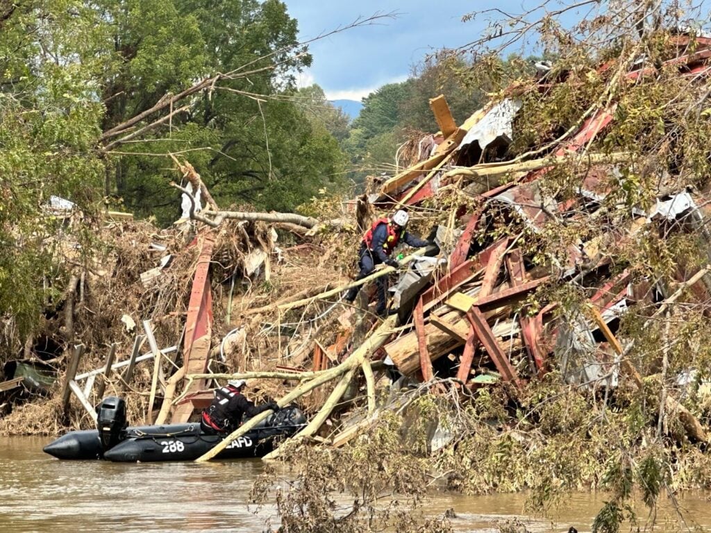
First responders clearing debris in western North Carolina after Hurricane Helene. Credit: LAFD Photo
These unique challenges inform the flood resilience policy roadmap for Appalachia, released earlier this year by NWF, Appalachian Citizens’ Law Center (ACLC), and ReImagine Appalachia.
The platform highlights federal policy recommendations to improve the ability of Appalachian communities to respond to and recover from floods—including ways to help low-income households. They include:
- Permanently authorize the Community Development Block Grant-Disaster Response (CDBG-DR) program, which provides grants for states, counties, local governments, Tribes, and territories to rebuild disaster-impacted areas and assist with long-term recovery. Permanent reauthorization would mean these funds could get to needy communities quicker—it currently takes, on average, nearly a year to allocate CDBG-DR funds post-disaster.
- Ensure more low and fixed-income residents can purchase flood insurance from FEMA’s National Flood Insurance Program (NFIP), via creation of a means-tested affordability framework. Flood insurance is a crucial piece of flood resilience, but its cost can be out-of-reach for lower income households. NFIP flood insurance premiums must also be paid in one lump sum annually, further exacerbating the challenge of budgeting for this cost. As Hurricane Helene’s impact has shown, many households outside of the mapped floodplain did not have flood insurance (in Buncombe County, for example, less than one percent of structures had flood insurance at the time of Helene’s landfall). It is crucial that flood premium rates are both accurate—accounting for a property’s current, true flood risk—and affordable.
Given the increased flood risks in Appalachia and the twin burdens of financial stress and cost-burdened households, greater action is needed to protect households who will continue to suffer from climate-related disasters in the coming decades.
Flood Mapping for Appalachia
Cross many parts of the U.S., flooding is becoming more frequent and more severe due to climate change. Which means flood mapping, which shows a community’s flood risk, is becoming a more important tool for homeowners, businesses, and government officials.
Federal investments in flood mapping, however, have not kept pace with the need or with increasing climate impacts. Thousands of U.S. communities lack maps, and about 15 percent of community flood maps are over 15 years old. More expansive and accurate maps are needed, particularly in communities across Appalachia, a region uniquely vulnerable to climate-induced flooding.
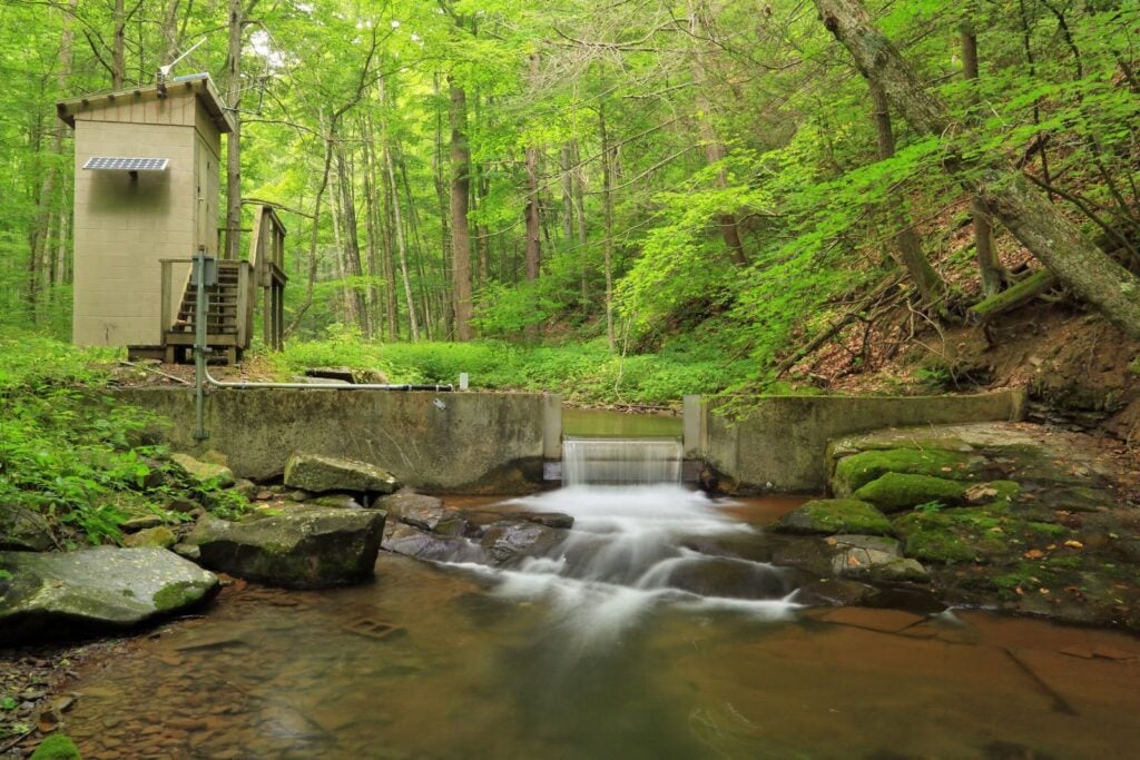
A USGS streamgage on Virginia’s Little Back Creek. Credit: Alan Cressler/USGS
Flood Mapping is Crucial for Flood-prone Appalachia
Besides providing crucial information for local development and emergency planning, flood mapping determines requirements for flood insurance. The National Flood Insurance Program (NFIP) requires the Federal Emergency Management Agency (FEMA) to update and maintain flood maps with respect to all populated areas and areas of population growth within 100-year and 500-year floodplains.
FEMA uses a mix of data sources from federal and state agencies, local development districts, and more to create its flood maps. The maps don’t always reflect the best available climate science or current climate impacts—especially the extreme rainfall events seen increasingly in Appalachia.
A 2020 report from the nonprofit flood risk group First Street Foundation identified nearly 15 million properties with a substantial risk of flooding, which is nearly 68 percent higher than the number of properties identified by FEMA. First Street used flooding from multiple sources (including rainfall and riverine), plus current and future environmental considerations, to calculate substantial flood risk. That inclusion of flood risk from rainfall helped drive the higher number of at-risk properties.
According to First Street, 45 percent of the parcels in the four counties that were most impacted by the July 2022 flooding disaster in Eastern Kentucky had a very high risk of flooding, but only 22 percent of those parcels were in a FEMA-designated flood zone.useholds who will continue to suffer from climate-related disasters in the coming decades.
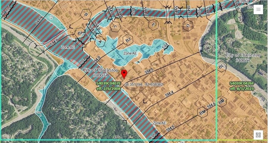
A screenshot of a FEMA flood map for Charleston, West Virginia.
Earlier this year, NWF, Appalachian Citizens’ Law Center (ACLC), and ReImagine Appalachia released a flood resilience policy roadmap for Appalachia. The platform highlights the unique flooding challenges the entire region faces, and details four sets of policy recommendations to improve Appalachian communities’ ability to respond to and recover from floods.
It covers recommendations on ways to improve flood mapping and data inputs, including:
- Deploy more streamgages in Appalachia. One of the key data sources used to create flood maps comes from the U.S. Geological Survey’s (USGS) streamgage network. This network is essential to ensure that communities are warned in time to evacuate areas affected by flooding. Flood alerts and predictions generated by the National Weather Service rely on data generated from USGS-managed streamgages. Streamgages can send alerts to residents to directly notify them of rising stream or water levels. And streamgage data can inform long-term resilience planning. Increasing funding for USGS would enable the agency to deploy additional streamgages, including in rural and disadvantaged communities.
- Modernize and expand FEMA floodmaps, so communities can know their accurate flood risk. Updated maps should account for anticipated climate impacts, and incorporate mapping of existing natural floodplain areas to understand where protective natural features exist and where they have been lost.
Learn more about the flood resilience policy roadmap for Appalachia here.
Nature-Based Solutions Needed to Combat Appalachia’s Growing Flood Risks
Boone County was once West Virginia’s premier coal producing county. Coal extraction in Boone increased from six million tons in 1950 to more than 32 million tons in 2000. But in 2003, devastation hit: Flood waters rushed down a mountaintop removal site, trapping a family in their home when their private bridge washed away. State officials blamed logging for the sudden rush of water, while federal regulators blamed the mine’s redesigned waste site that increased risks for minor flooding. It’s just one example of the impacts of natural resource extraction.
Conventional Land Reclamation isn’t Enough
Extensive logging and mining has left visible scars throughout Appalachia, but those scars have never fully healed. Patterns of development in the region—with many residents living alongside rivers and streams—combined with this history of extraction, and increasing climate impacts, make Appalachia uniquely vulnerable to flooding.
A great crested flycatcher visits a tree in West Virginia’s Monongahela National Forest. Parts of the forest were previously mine lands, and have been restored. Credit: Alicia Pimental/Chesapeake Bay Program
Companies are required to reclaim surface and underground coal mine sites permitted before 1977. But conventional reclamation has repeatedly shown to be ineffective at returning mine lands to their original ecologic and hydrologic functionality. Reclaimed soils are thinner, reducing the ability of the land to absorb and store water. Instead of native vegetation, mining companies often plant hardy conifers or grassland plants. Modeling suggests that reclamation can result in an almost “impervious” surface similar to a city.
Heavy logging, too, can play a role in Appalachia’s flood risk. Tree roots and a tree’s ability to soak up water from the soil help stabilize steep slopes in mountainous regions like Appalachia. Yet throughout Appalachia, few states currently have Best Management Practices in place for logging to help reduce landslides.
A Cheat Mountain salamander. This species is endemic to West Virginia, and an example of the kind of unique wildlife that can benefit from ecologically appropriate mine reclamation. Credit: Kerry Wixted
Investments in nature-based solutions are needed to restore and protect Appalachia’s landscape—and to better protect Appalachian communities and build long-term climate resilience. Earlier this year, NWF, the Appalachian Citizens’ Law Center, and ReImagine Appalachia released a flood resilience policy roadmap for Appalachia. The platform highlights the unique flooding challenges the entire region faces, and details four sets of policy recommendations to improve flood resilience and recovery for Appalachia.
Recommendations related to nature-based hazard mitigation include:
- Invest in the Appalachian Regional Reforestation Initiative (ARRI), a cooperative effort between the public and private sector to facilitate ecologically appropriate mineland reclamation. Despite a record of success—ARRI has reclaimed over 60,000 acres of mine lands and planted more than 20 million trees—the initiative has never had dedicated federal funding.
- Increase funding for popular, oversubscribed conservation programs at the U.S. Department of Agriculture, such as the Conservation Stewardship Program. Agricultural practices play an important role in flood resilience efforts: Nearly 30 percent of land in Appalachia is devoted to agriculture, largely small-scale family farms. Supporting climate-smart agriculture not only helps farmers and wildlife, it can protect water quality and reduce the severity of floods.
Incentivize nature-based hazard mitigation projects, including by requiring states to consider nature-based solutions as potential mitigation techniques in state hazard mitigation plans, and setting aside a portion of funding in the federal Building Resilient Infrastructure and Communities program for nature-based hazard mitigation projects.